
Venues
This section provides participants, teams, and visitors with all the essential information about the competition and support venues of the 2026 FISU World University Championship Orienteering. Here you will find practical details to help you plan your visit, access the various terrains and mapped areas, consult venue maps and technical guidelines, and learn about the services available at each location.
The competition areas are located in the surroundings of Vila Real, in Northern Portugal, at altitudes typically ranging between 500 and 900 meters above sea level.
URBAN TERRAIN – Sprint competitions
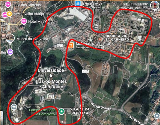
The Sprint competitions will take place in Vila Real, in a vibrant and challenging urban area marked by a dense and complex network of streets. The course passes through the historic center, with tight streets and irregular blocks, and by residential areas, which combine open courtyards, small green spaces, and passages between buildings.
The urban environment is multi-level, including stairs, ramps, and underground passages, with a variety of surfaces, from asphalt to granite pavement. The high density of route options and frequent changes of direction require quick decision-making and precision in choosing the route (characteristics typical of the university campus orienteering style).
The maps for the events have been carefully prepared by the Portuguese cartographer José Maia, following the latest IOF International Specification for Sprint Maps (ISSprOM), with a scale of 1:4,000 and a contour interval of 2.5 meters, ensuring maximum accuracy and quality for athletes and the public.
FORREST TERRAIN – Middle Distance competitions
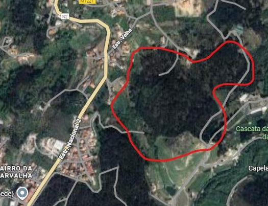
The forest terrain where the Middle Distance competitions will take place is technically challenging and varied, located in a military training area in Vila Real. Athletes will cross a diverse landscape, with dense pine forests, scattered chestnut and oak trees, and moderate to steep slopes.
Along the route, there are impressive rock formations, such as blocks, outcrops, and escarpments, as well as historical remains from the region, including old trenches and linear earth structures. Some areas, especially in the deeper valleys, have dense vegetation that is difficult to traverse, such as blackberry thickets and Genista bushes, making navigation even more challenging.
The runnability varies along the course, alternating between open, fast areas and technical sections that require precision and strategy. This diversity offers a unique orienteering experience, combining speed, decision-making, and technique.
The maps for this competition have been carefully prepared by the Portuguese cartographer Rafael Miguel, following the latest IOF International Specification for Orienteering Maps (ISOM), with a scale of 1:7,500 (with regulatory deviation requested) and a contour interval of 5 meters, ensuring maximum accuracy and quality for athletes and the public.
EMBARGOED AREAS
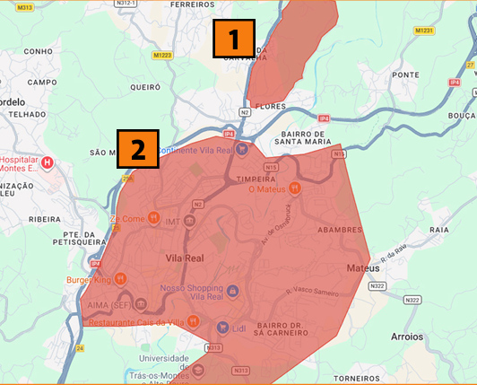
There are areas that are completely off-limits to competitors, team officials, or anyone who, due to their knowledge of the terrain, could influence the results of the competitions. These areas are essential to ensuring the fairness and integrity of the event.
The restricted areas include:
1. Embargoed area for the Middle Distance competition;
2. Embargoed area for the Sprint competition.